- Home
- Getting Started
- Documentation
- Release Notes
- Tour the Interface
- Tour the Layers
- JMARS Video Tutorials
- Lat/Lon Grid Layer
- Map Scalebar
- Nomenclature
- Crater Counting
- 3D
- Shape Layer
- Mosaics
- Map
- Advanced/Custom Maps
- Graphic/Numeric Maps
- Custom Map Sharing
- Stamp
- THEMIS
- MOC
- Viking
- CRISM Stamp Layer
- CTX
- HiRise
- HiRISE Anaglyph
- HiRISE DTM
- HRSC
- OMEGA
- Region of Interest
- TES
- THEMIS Planning
- Investigate Layer
- Landing Site Layer
- Tutorials
- Video Tutorials
- Displaying the Main View in 3D
- Finding THEMIS Observation Opportunities
- Submitting a THEMIS Region of Interest
- Loading a Custom Map
- Viewing TES Data in JMARS
- Using the Shape Layer
- Shape Layer: Intersect, Merge, and Subtract polygons from each other
- Shape Layer: Ellipse Drawing
- Shape Layer: Selecting a non-default column for circle-radius
- Shape Layer: Selecting a non-default column for fill-color
- Shape Layer: Add a Map Sampling Column
- Shape Layer: Adding a new color column based on the values of a radius column
- Shape Layer: Using Expressions
- Using JMARS for MSIP
- Introduction to SHARAD Radargrams
- Creating Numeric Maps
- Proxy/Firewall
- JMARS Shortcut Keys
- JMARS Data Submission
- FAQ
- Open Source
- References
- Social Media
- Podcasts/Demos
- Download JMARS
JMARS release 5.6.3
JMARS release 5.6.3 brings smarter data export and import, better Shape tools, and a more helpful user interface.
JMARS Release 5.6.3: Smarter Coordinates, Better Shape Tools, and a More Helpful User Interface
We’ve rolled out a major set of improvements that make working with shapes, coordinates, and measurements more accurate, flexible, and intuitive. This update enhances both data import/export workflows and on-screen productivity tools across the Shape Layer and the broader user interface.
New Coordinate & Shape Handling Improvements in JMARS
We’ve added powerful upgrades to make working with shapes, CSVs, and SHP files smoother and more flexible:
Coordinate formats now match your preferences
The Feature Table will display longitude/latitude values in whatever coordinate format you choose. JMARS handles the internal details for you.
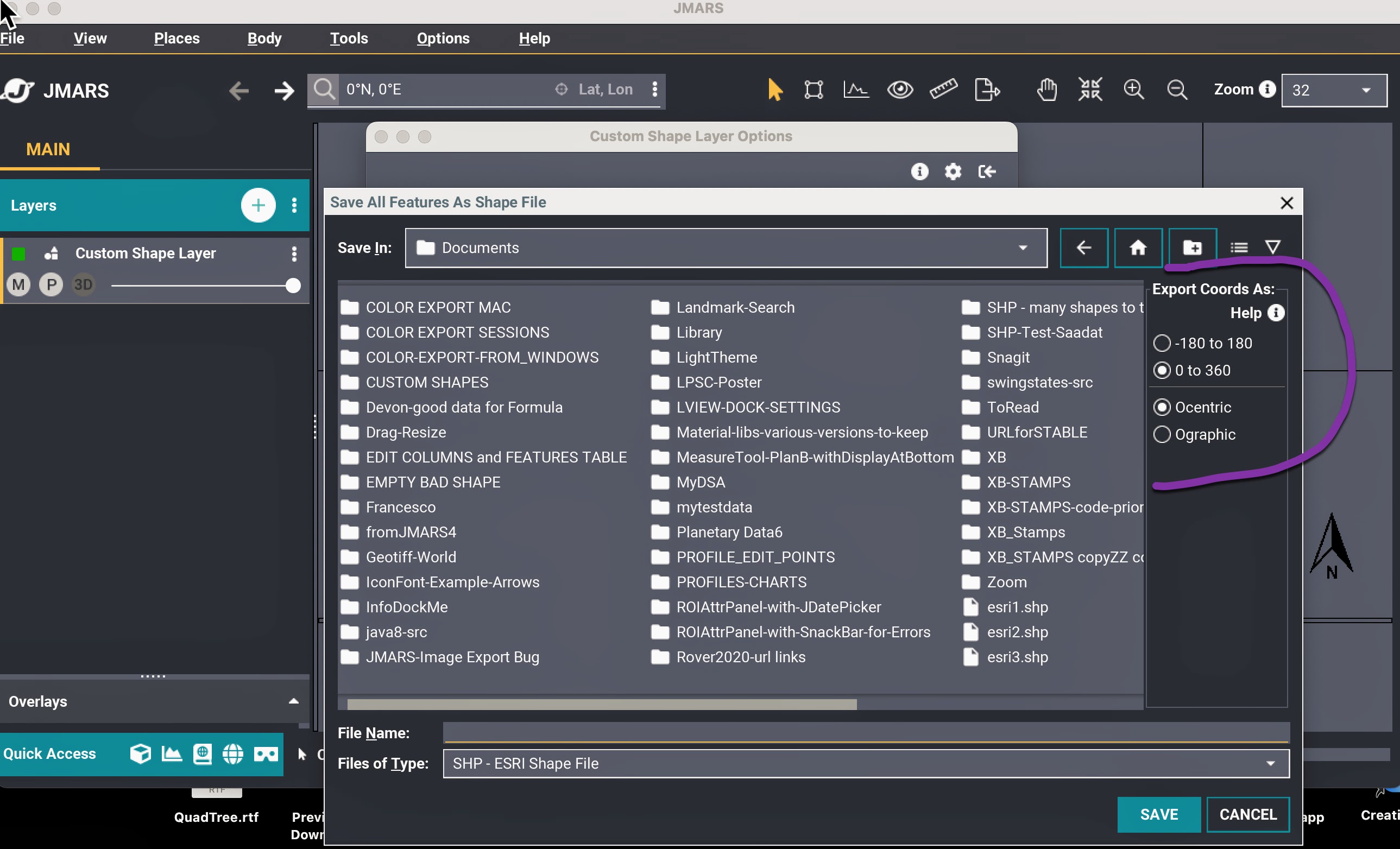
More control when exporting CSV and SHP files
When exporting shapes to CSV or SHP, you can now choose:
-
How longitude values are expressed (East-leading or West-leading)
-
Whether to use 0–360 or –180 to 180 ranges
-
Whether coordinates are ocentric or ographic
-
How to export geometry for shapes
These export options are independent of your in-app coordinate preferences—so you can work one way in JMARS and export another.
(Note: SHP files always use East-leading longitude per ESRI standards, but you can still choose the range and ocentric/ographic setting.)
Smarter imports for CSV and SHP files
When importing CSVs, you can now tell JMARS:
-
Whether the file uses East or West leading longitude
-
Whether latitude values are ocentric or ographic
JMARS automatically handles 0–360 vs –180–180, so you don’t need to specify it.
For SHP imports, you’ll choose between ocentric and ographic latitude—East-leading longitude is assumed since SHP files always use it.
Better support for circles and ellipses
During import (CSV or SHP), you can specify if the file contains circles or ellipses.
This helps JMARS properly prepare the shapes for editing.
If JMARS needs clarification, it will prompt you to select which fields to use.
Find these options in File Chooser dialog when working with files in Custom Shape layer.
UI Improvements & Expanded Measurement Tools
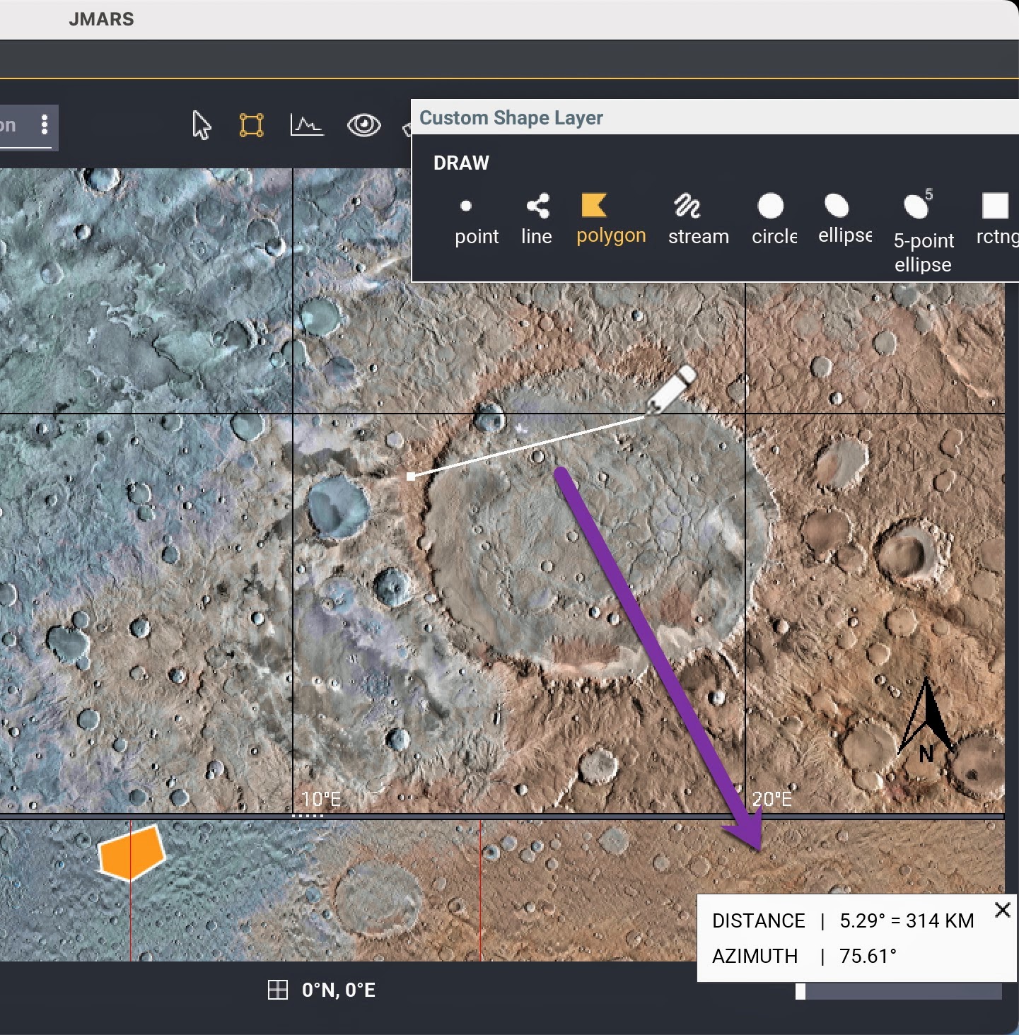
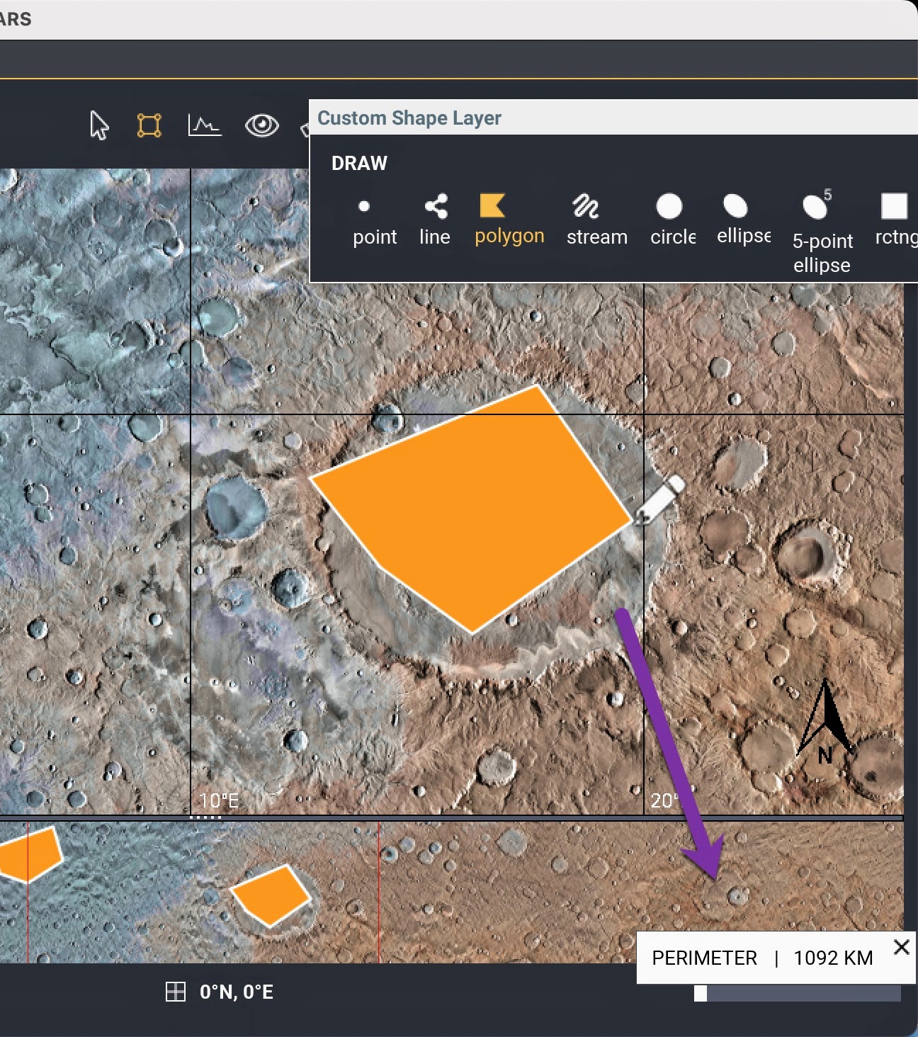
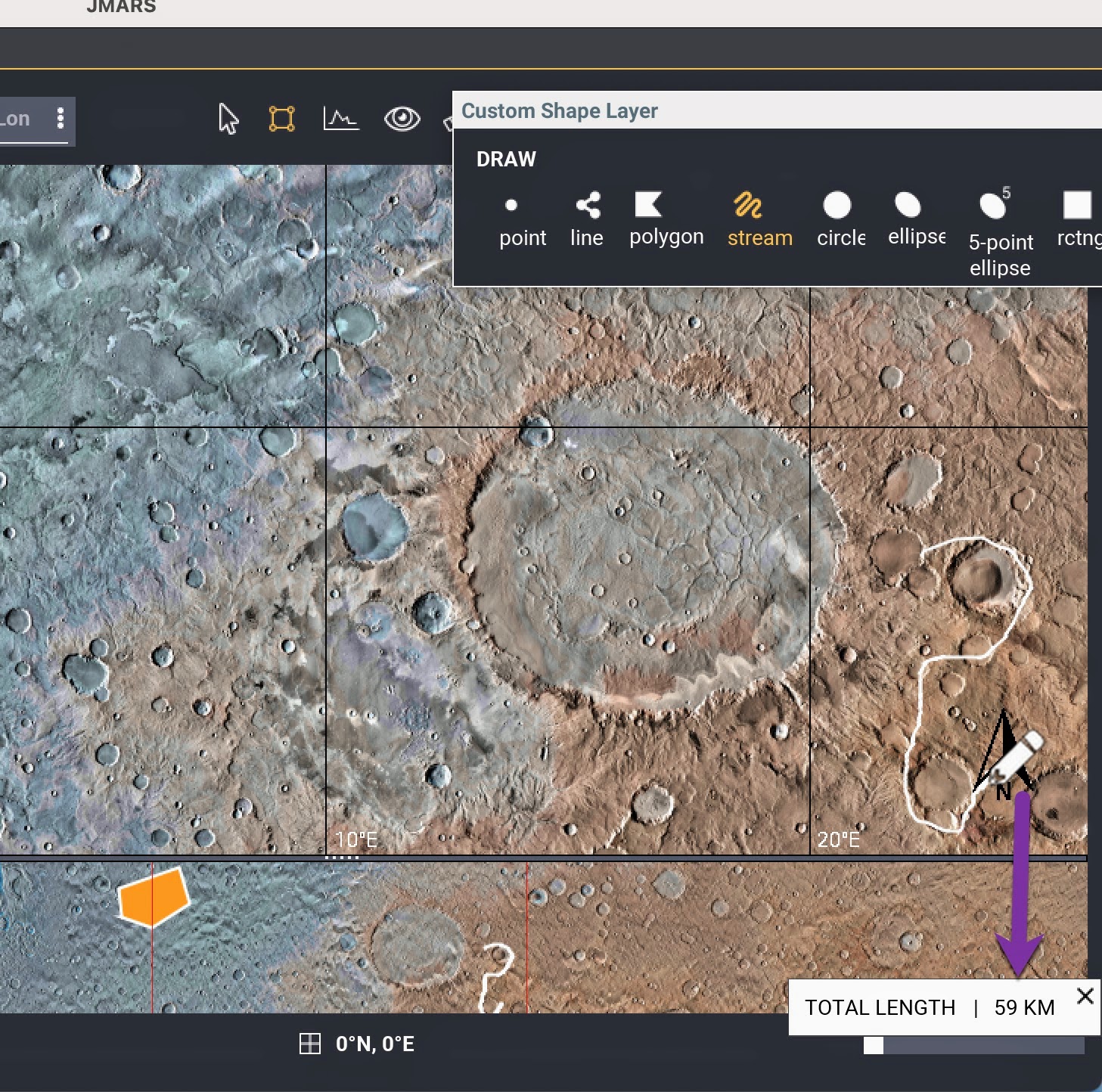
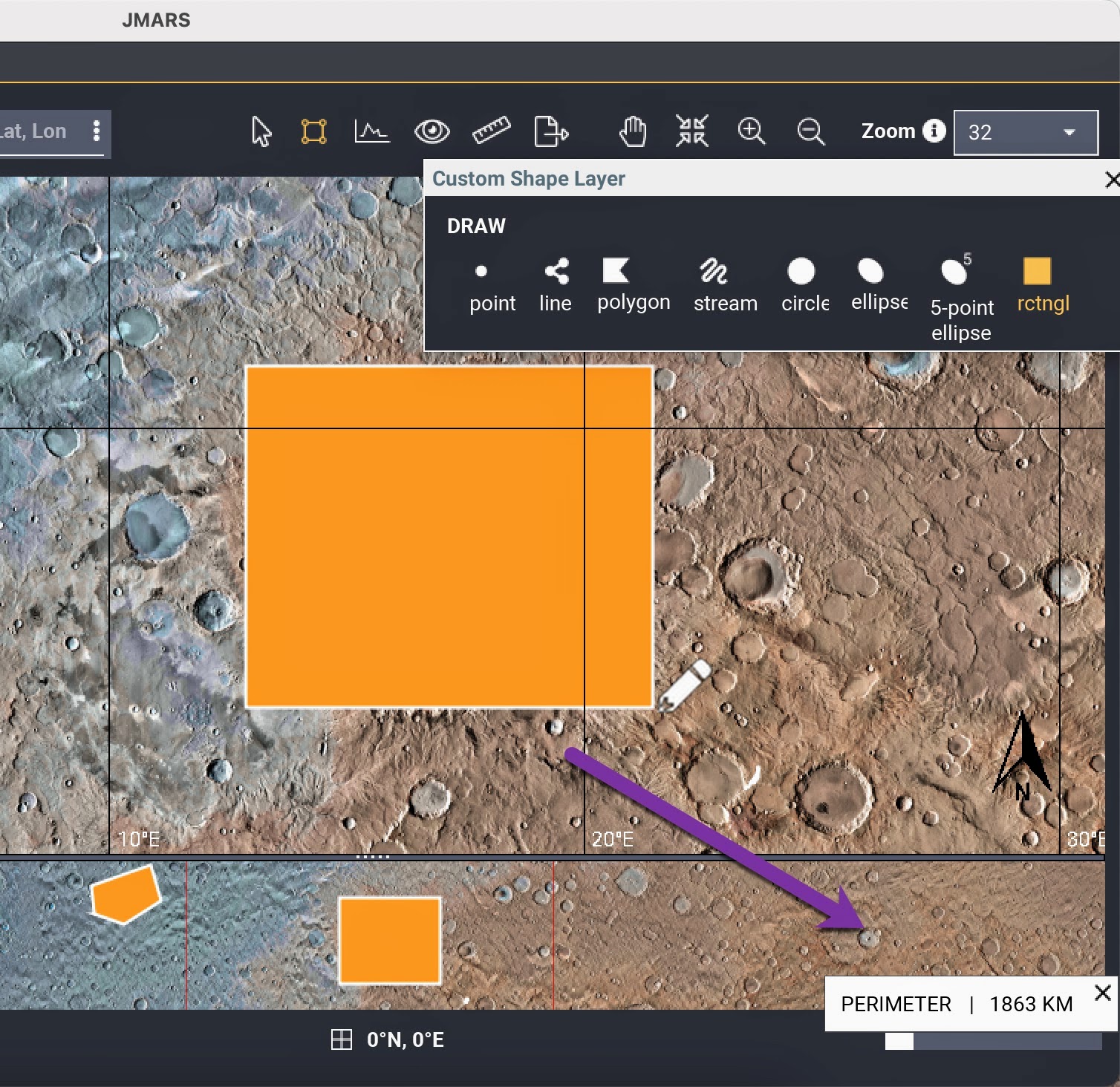
1) Richer measurement readouts
Distance and geometry tools now report:
-
Azimuth
-
Total length for polylines and open streams
-
Perimeter for polygons, rectangles, ellipses, closed streams, and 5-point ellipses
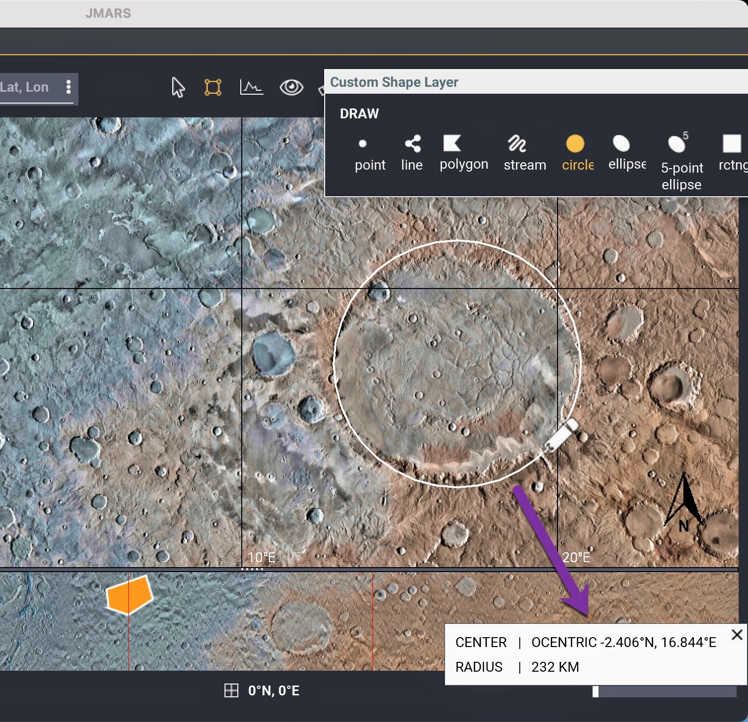
2) Real-time circle information
While drawing circles, JMARS now displays:
-
Center coordinates
-
Radius
-
This makes precise placement fast and intuitive.
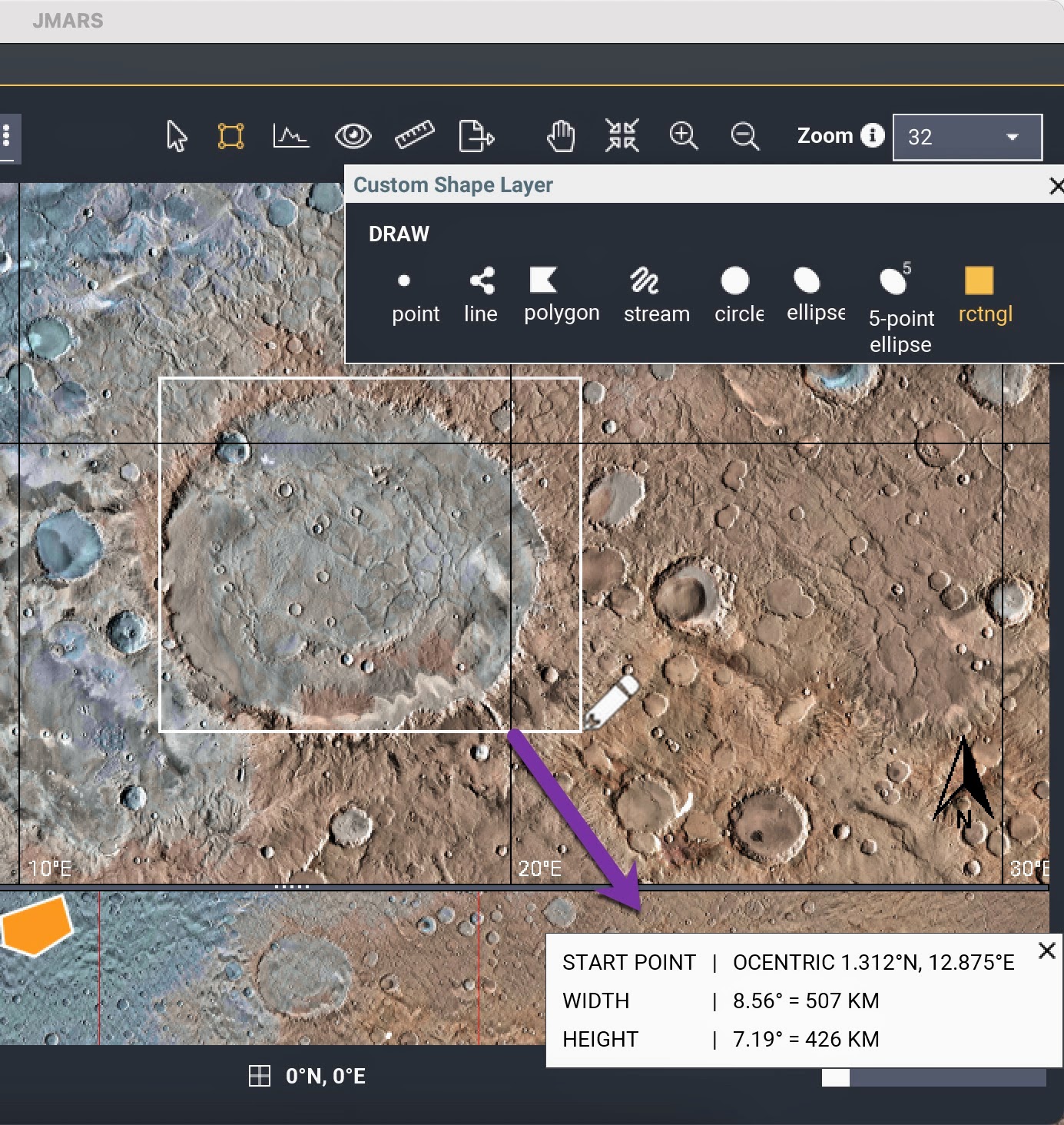
3) Real-time rectangle metrics
When drawing rectangles, you’ll now see:
-
Starting coordinate
-
Width
-
Height
4) Multi-selection with CTRL+Click
In the Custom Shape Layer, you can now CTRL+click to select multiple shapes directly in the main view, with full two-way sync to the Feature Table.
5) Multiple CTRL+drag selection windows
You can draw more than one selection box while holding CTRL, allowing flexible, multi-region shape selection.
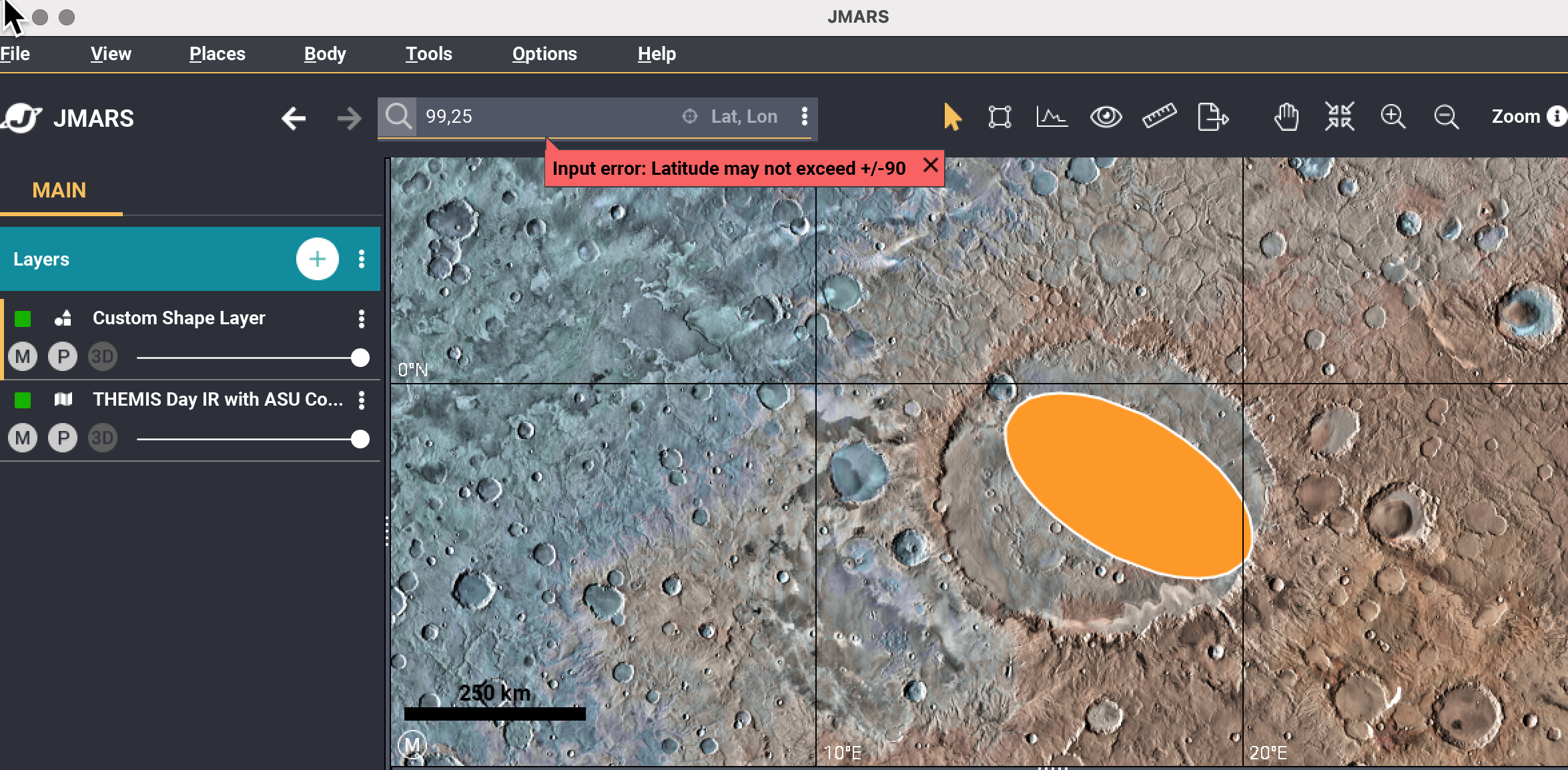
6) Better validation & clearer notifications
Latitude/longitude entry and Place bookmarking now have improved validation and user-friendly alerts to help avoid invalid inputs.