
- Home
- Getting Started
- Documentation
- Release Notes
- Tour the Interface
- Tour the Layers
- JMARS Video Tutorials
- Lat/Lon Grid Layer
- Map Scalebar
- Nomenclature
- Crater Counting
- 3D
- Shape Layer
- Mosaics
- Map
- Advanced/Custom Maps
- Graphic/Numeric Maps
- Custom Map Sharing
- Stamp
- THEMIS
- MOC
- Viking
- CRISM Stamp Layer
- CTX
- HiRise
- HiRISE Anaglyph
- HiRISE DTM
- HRSC
- OMEGA
- Region of Interest
- TES
- THEMIS Planning
- Investigate Layer
- Landing Site Layer
- Tutorials
- Video Tutorials
- Displaying the Main View in 3D
- Finding THEMIS Observation Opportunities
- Submitting a THEMIS Region of Interest
- Loading a Custom Map
- Viewing TES Data in JMARS
- Using the Shape Layer
- Shape Layer: Intersect, Merge, and Subtract polygons from each other
- Shape Layer: Ellipse Drawing
- Shape Layer: Selecting a non-default column for circle-radius
- Shape Layer: Selecting a non-default column for fill-color
- Shape Layer: Add a Map Sampling Column
- Shape Layer: Adding a new color column based on the values of a radius column
- Shape Layer: Using Expressions
- Using JMARS for MSIP
- Introduction to SHARAD Radargrams
- Creating Numeric Maps
- Proxy/Firewall
- JMARS Shortcut Keys
- JMARS Data Submission
- FAQ
- Open Source
- References
- Social Media
- Podcasts/Demos
- Download JMARS
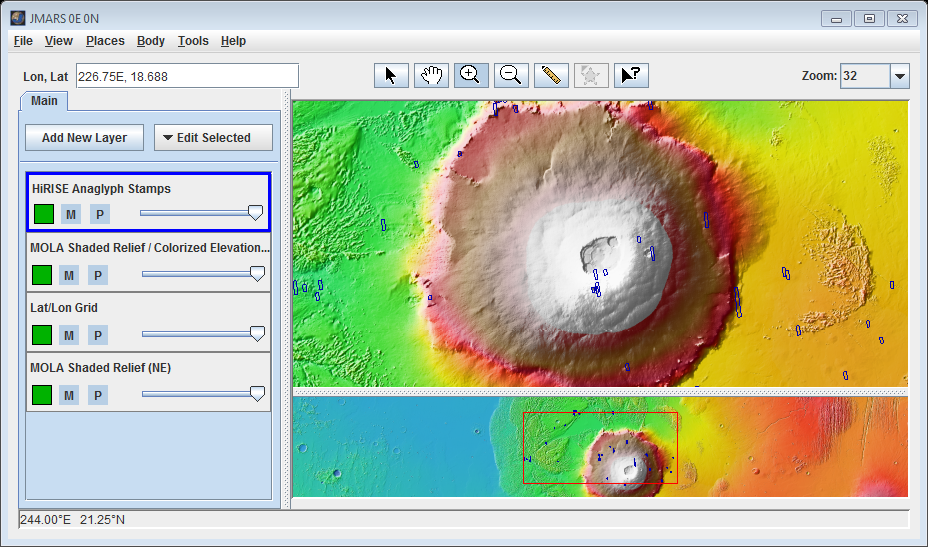
High Resolution Imaging Science Experiment (HiRISE) Anaglyph Stamp Layer
The HiRISE Anaglyph Stamp Layer will display stamps for all anaglyph products produced by the High Resolution Imaging Science Experiment (HiRISE) science team. While the search interface is similar to the THEMIS Stamp Layer, there are some differences that allow users to search for HiRISE anaglyph products based on the unique parameters associated with both HiRISE images and anaglyph products.
Open the HiRISE Anaglyph Stamp Layer
- Open the Stamp Layer: Chose "Add New Layer" -> "Instument" -> "HiRISE Anaglyph". OR "Add New Layer" -> "Imagery: -> "HiRISE Anaglyph"
- Enter Search Parameters: Since there are so few HiRISE Anaglyph products currently available, the only necessary search parameters are Image ID and Latitude/Longitude. The allowable values for each field are given in the quick reference table below followed by more detailed descriptions of each search parameter.
- Perform Image Search: Clicking OK will make the Stamp Layer perform the search and display the results. Once the stamps are displayed in the Viewing Window, users can right-click on an outline to either render the image (display the image data in JMARS) or view the image in a web browser.In either case, users can view the 3D anaglyph data using standard red-blue 3D glasses.
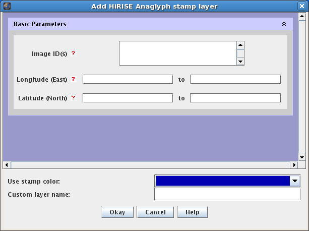
HiRISE Anaglyph Search Parameter Glossary
|
Filter Type |
Acceptable Values |
Description |
|
Image ID(s) |
Any Specific Image ID Number(s) |
A unique identifier for each anaglyph product. The Image ID is a back-to-back combination of the individual Image IDs of both HiRISE images used to produce the product, excluding the filter information. The anaglyph Image IDs follow the pattern PPP_NNNNNN_TTT_PPP_NNNNNN_TTT, where:
|
|
Min/Max Longitude |
0 to 360(East Longitude = Positive) |
This is the approximate longitude on the planet Mars of the image center. All values are based on the IAU 2000 aerocentric model of Mars with east positive longitude. |
|
Min/Max Latitude |
90 to -90(North Latitude = Positive) |
This is the approximate latitude on the planet Mars of the image center. All values are based on the IAU 2000 aerocentric model of Mars with north positive latitude. |


Stamp Layer Functions
The HiRISE Anaglyph Stamp Layer's functions are identical to the functions of the Stamp Layer and are explained in detail on the Stamp Layer page.