
- Home
- Getting Started
- Documentation
- Release Notes
- Tour the Interface
- Tour the Layers
- JMARS Video Tutorials
- Lat/Lon Grid Layer
- Map Scalebar
- Nomenclature
- Crater Counting
- 3D
- Shape Layer
- Mosaics
- Map
- Advanced/Custom Maps
- Graphic/Numeric Maps
- Custom Map Sharing
- Stamp
- THEMIS
- MOC
- Viking
- CRISM Stamp Layer
- CTX
- HiRise
- HiRISE Anaglyph
- HiRISE DTM
- HRSC
- OMEGA
- Region of Interest
- TES
- THEMIS Planning
- Investigate Layer
- Landing Site Layer
- Tutorials
- Video Tutorials
- Displaying the Main View in 3D
- Finding THEMIS Observation Opportunities
- Submitting a THEMIS Region of Interest
- Loading a Custom Map
- Viewing TES Data in JMARS
- Using the Shape Layer
- Shape Layer: Intersect, Merge, and Subtract polygons from each other
- Shape Layer: Ellipse Drawing
- Shape Layer: Selecting a non-default column for circle-radius
- Shape Layer: Selecting a non-default column for fill-color
- Shape Layer: Add a Map Sampling Column
- Shape Layer: Adding a new color column based on the values of a radius column
- Shape Layer: Using Expressions
- Using JMARS for MSIP
- Introduction to SHARAD Radargrams
- Creating Numeric Maps
- Proxy/Firewall
- JMARS Shortcut Keys
- JMARS Data Submission
- FAQ
- Open Source
- References
- Social Media
- Podcasts/Demos
- Download JMARS
Ocentric vs Ographic latitudes
Ocentric vs Ographic Latitude
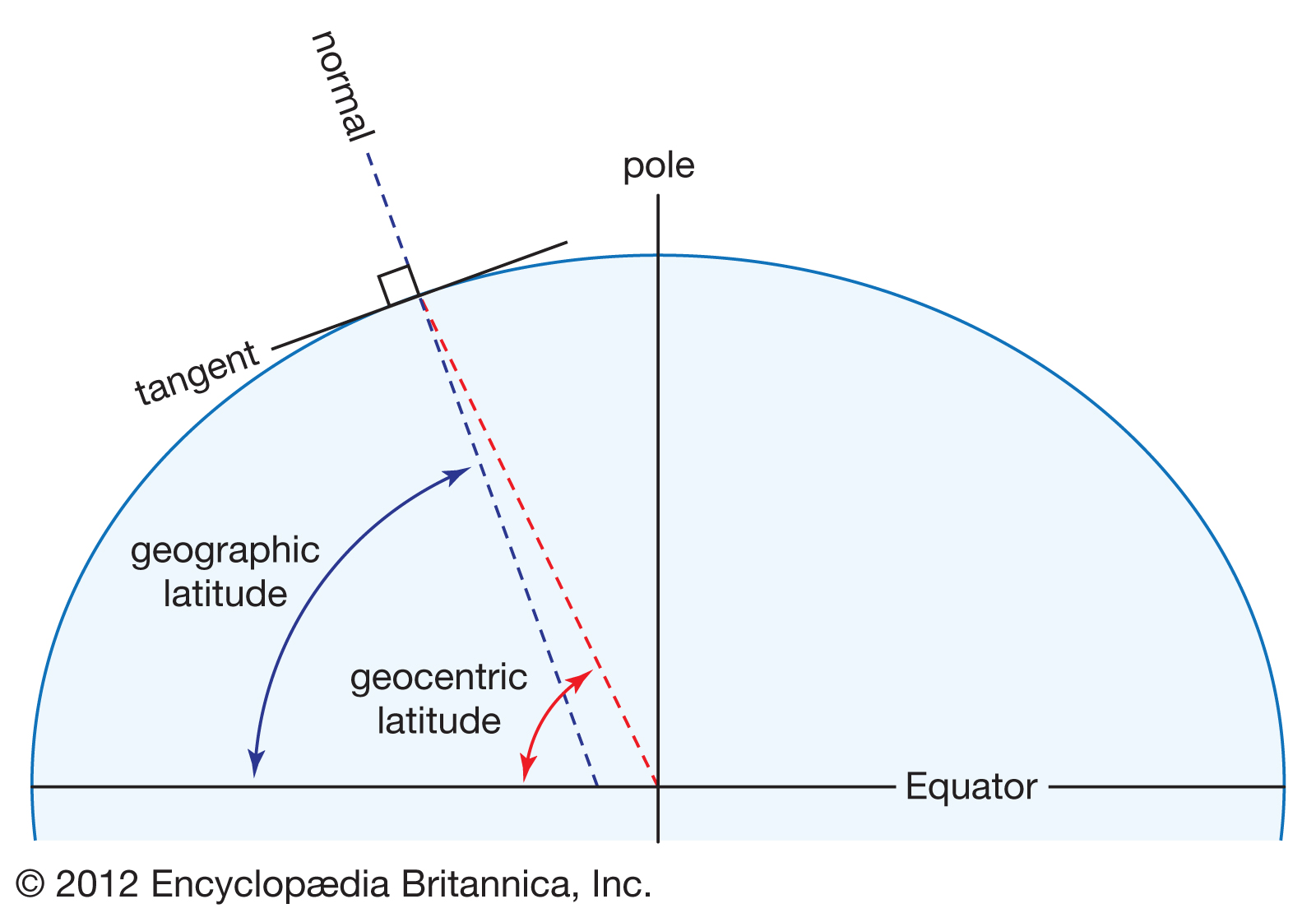
Latitude can be defined in two common ways: ocentric and ographic. Ocentric latitude is measured from the equatorial plane using a line drawn from the center of the body to the surface point (center-of-body latitude). Ographic latitude is measured from the equatorial plane using the surface normal (a line perpendicular to the body’s reference shape at that point). On a body represented by an ellipsoid (or other non-spherical reference shape) they differ, with the maximum difference occurring near mid-latitudes (around 45°).
1) The two latitude types
Ocentric latitude
Also called: planetocentric (planets), geocentric (Earth)
- Uses a line from the planet’s center to the surface point.
- Think: “angle from the equator as seen from the center.”
Ographic latitude
Also called: planetographic (planets), geodetic (Earth), and often “geographic latitude”
- Uses the surface normal (perpendicular to the body’s reference shape) at that point.
- Think: “latitude based on the reference surface.”
Note about “geographic”: The word “geographic” is used loosely in many GIS contexts to mean “lat/long,” and that latitude is typically geodetic—which corresponds to ographic.

2) Reference shape matters
The quickest way to think about this is by the shape your data assumes:
- If your data is tied to an ellipsoid (flattened sphere) reference shape, it is almost always using ographic latitude (surface-normal / geodetic-style latitude).
- If your data is tied to a sphere reference shape, it is often using ocentric latitude (center-of-body latitude).
On a perfect sphere the two definitions produce the same numeric latitude values; the difference shows up when the reference shape is not spherical.
3) Common confusion
This is only about the definition of latitude. It is not the same as:
- choosing whether longitude is positive east or positive west
- choosing whether longitude is 0–360 or −180–180
- choosing a map projection (equirectangular, polar stereographic, etc.)
Those are separate settings. You can have the right longitude/projection and still be wrong on ocentric vs ographic (and vice versa).
4) Which option should I pick? (simple guidance)
If you are working with Earth
Earth data can be referenced to a sphere or an ellipsoid, but most Earth GIS data uses an ellipsoid, which corresponds to ographic latitude.
Most likely correct on Earth: ographic
If you are working with a planetary body other than Earth
Non-Earth datasets vary, but many modern planetary products are commonly distributed in ocentric (planetocentric) coordinates.
Most likely correct for non-Earth planetary data: ocentric
If your dataset explicitly says planetographic (or uses a defined ellipsoid and states geodetic/planetodetic), then choose ographic.
Best rule (when the metadata is clear)
- If the dataset says planetocentric / geocentric → choose ocentric
- If the dataset says planetographic / geodetic → choose ographic
5) Quick validation checklist
- Check a few known features (craters, dataset seams, landmark points).
- If the map is consistently shifted north/south (but longitude looks right), you likely picked the wrong latitude type. Switching ocentric ↔ ographic often fixes a clean north/south offset.
- If the map looks mirrored or shifted east/west, that is more likely a longitude convention or projection issue, not ocentric/ographic.
One-sentence summary
Ocentric = planetocentric = geocentric (center-of-body latitude)
Ographic = planetographic = geodetic (surface-normal latitude; often what people mean by “geographic latitude”)
For more information:
Image one is from Encyclopaedia Britannica, Inc, https://www.britannica.com/science/latitude
Image two is from Proj, https://proj.org/operations/conversions/geoc.html