
- Home
- Getting Started
- Documentation
- Release Notes
- Tour the Interface
- Tour the Layers
- JMARS Video Tutorials
- Lat/Lon Grid Layer
- Map Scalebar
- Nomenclature
- Crater Counting
- 3D
- Shape Layer
- Mosaics
- Map
- Advanced/Custom Maps
- Graphic/Numeric Maps
- Custom Map Sharing
- Stamp
- THEMIS
- MOC
- Viking
- CRISM Stamp Layer
- CTX
- HiRise
- HiRISE Anaglyph
- HiRISE DTM
- HRSC
- OMEGA
- Region of Interest
- TES
- THEMIS Planning
- Investigate Layer
- Landing Site Layer
- Tutorials
- Video Tutorials
- Displaying the Main View in 3D
- Finding THEMIS Observation Opportunities
- Submitting a THEMIS Region of Interest
- Loading a Custom Map
- Viewing TES Data in JMARS
- Using the Shape Layer
- Shape Layer: Intersect, Merge, and Subtract polygons from each other
- Shape Layer: Ellipse Drawing
- Shape Layer: Selecting a non-default column for circle-radius
- Shape Layer: Selecting a non-default column for fill-color
- Shape Layer: Add a Map Sampling Column
- Shape Layer: Adding a new color column based on the values of a radius column
- Shape Layer: Using Expressions
- Using JMARS for MSIP
- Introduction to SHARAD Radargrams
- Creating Numeric Maps
- Proxy/Firewall
- JMARS Shortcut Keys
- JMARS Data Submission
- FAQ
- Open Source
- References
- Social Media
- Podcasts/Demos
- Download JMARS
Loading a Custom Map
Upload your image to JMARS through the custom map upload process. You can do this by either entering your points manually or using the geospatial upload button. NOTE: In order to use the Custom Map Upload, you must sign into JMARS using your username and password. Otherwise these options will not be available to use
Open JMARS
- Start JMARS
- Enter your JMARS user name and password. If you do not have a user name and password, follow the instruction under the appropriate "Getting Started" link on the Main Page.
- At this point, the Layer Manager should only have the MOLA Shaded Relief Layer, Nomenclature and the Lat/Lon Layer loaded.
Load The Image
- In order to start the process go to the "Add new Layer" in the Layer manager.
- Then scroll down to "Upload Custom Map". This will open a new window to upload your image.

- In the first box, enter your path to your image or press the "Browse" button to find and select your image
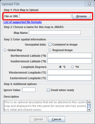
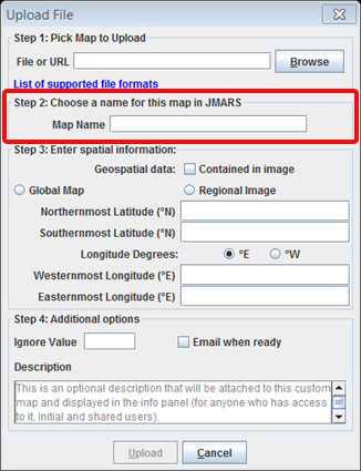
- In the second box, name your image. This name will appear on your newly created layer in your layer manager.
- You have three options when uploading your image:
-The first is Global Map upload. If your image is a global image, you can select the "Global Map" button. This will automatically fill in the corner points for you.

-The next option is to upload the image manually. If your image does not have geospatial information, you can manually enter the corner points. First select the "Regional Image" button and then insert the coordinate below

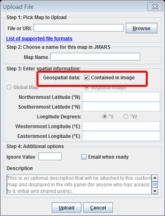
-The last option is to upload your image using the geospatial import button. Select the "contained in image" checkbox and then press upload. Again, this option will only work if your image has geospatial information and a projection. NOTE: As long as your image is recognized correctly by GDAL, the image can be a different projection other than JMARS. JMARS will convert it to an Equirectangular projection on the backend. Also, the image may take a an extended amount of time to upload if it is a larger image. Currently, images larger than 2G cannot be uploaded through this process.
Editing the Custom Map Settings
- In the Layer Manager, double-click on the tab named after the custom map that you just uploaded to access its focus panel. Then click on the "Input" tab.

- If you click "Center" JMARS will center over the image.
- Using the arrow keys in the "Input" window, you can shift the custom map in any direction by pixels. (Since the pixel number in the center of the arrows is set to "1", each click of an arrow will move the custom map in that direction by one pixel.
- To go back to the original position, click the "Reset" button next to the arrow keys to return the map to its original position.
- Keep in mind that JMARS will automatically save the moved image, so if you do not want to save the new location press the "Reset" button.
Deleting the Custom Map
- Navigate to the Advanced Maps and click it to open a new window. "Add New Layer" --> "Advanced Maps"
- In the "Available Maps" section of the Settings window, under "Mars Spaceflight Facility Custom MapServer", click on the image you wish to permanently delete.
- Click "Delete Map", which will remove the custom map from the Custom Map Server
Congratulations! You have finished the fifth JMARS tutorial!
PREVIOUS: Submitting a THEMIS Region of Interest (ROI) NEXT: Loading a Custom Map with Advanced Maps