
- Home
- Getting Started
- Documentation
- Release Notes
- Tour the Interface
- Tour the Layers
- JMARS Video Tutorials
- Lat/Lon Grid Layer
- Map Scalebar
- Nomenclature
- Crater Counting
- 3D
- Shape Layer
- Mosaics
- Map
- Advanced/Custom Maps
- Graphic/Numeric Maps
- Custom Map Sharing
- Stamp
- THEMIS
- MOC
- Viking
- CRISM Stamp Layer
- CTX
- HiRise
- HiRISE Anaglyph
- HiRISE DTM
- HRSC
- OMEGA
- Region of Interest
- TES
- THEMIS Planning
- Investigate Layer
- Landing Site Layer
- Tutorials
- Video Tutorials
- Displaying the Main View in 3D
- Finding THEMIS Observation Opportunities
- Submitting a THEMIS Region of Interest
- Loading a Custom Map
- Viewing TES Data in JMARS
- Using the Shape Layer
- Shape Layer: Intersect, Merge, and Subtract polygons from each other
- Shape Layer: Ellipse Drawing
- Shape Layer: Selecting a non-default column for circle-radius
- Shape Layer: Selecting a non-default column for fill-color
- Shape Layer: Add a Map Sampling Column
- Shape Layer: Adding a new color column based on the values of a radius column
- Shape Layer: Using Expressions
- Using JMARS for MSIP
- Introduction to SHARAD Radargrams
- Creating Numeric Maps
- Proxy/Firewall
- JMARS Shortcut Keys
- JMARS Data Submission
- FAQ
- Open Source
- References
- Social Media
- Podcasts/Demos
- Download JMARS
JMARS release 5.5.4
JMARS 5.5.4 brings enhancements to Custom Shape and Crater Counting layers, fixes image export with transparency, and expands high-resolution export to include PNG and TIFF.
JMARS 5.5.4 Release Notes
We're excited to share the latest updates to JMARS! This release focuses on highly requested improvements to the Custom Shape and Crater Counting layers, along with a fix to an image with transparency export.
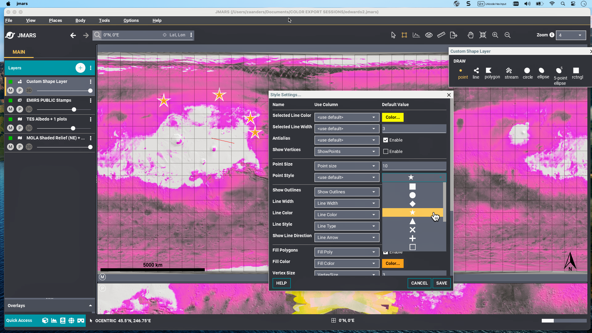
1. Custom Shape Layer: More Point Styles
When marking locations using points in the Custom Shape layer, you can now choose from seven distinct point shapes, including stars, triangles, circles, and more. Each shape can be drawn as either filled or outlined, helping you clearly differentiate between map features or categories during your analysis.
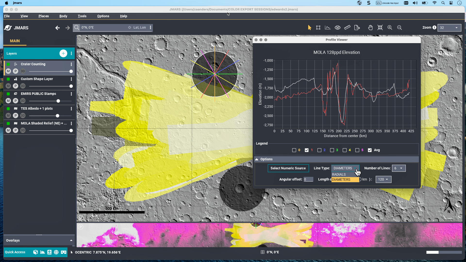
2. Crater Counting Layer: More Flexibility in Profile Drawing
You can now choose between radial and diameter profiles when analyzing craters—giving you more control over how features are measured and visualized. The Profile Viewer now offers an interactive legend, allowing you to easily show or hide individual profiles.
3. The High-Resolution export feature has been expanded: previously limited to JPEG, it now supports PNG and TIFF formats, offering more flexible output options.

4. Image with Transparency Export (bug fix)
We've fixed an issue affecting JPEG, PNG, TIFF, and High-Resolution exports, where images with transparency settings appeared washed-out or darkened. Exported images now retain their correct colors and transparency, accurately reflecting the on-screen display.